Ak-Attack Resources
The Map
Each rider will receive 2 maps for the event. They will be A3 and have a scale of around 1:25000 depending on the course design. There will be an overlap between to let you use one or other depending on where you are riding. They may include enlargements of small areas where there are lots of tracks.
These maps have been specially created for the event and provide more useful detail to mountain bike riders than is found on a normal topographical map. A team of riders has been all over the area to ensure the accuracy of the tracks and especially the junctions. There are probably some tracks we haven't found yet, but we think we have the best map of the Aka's that there is.
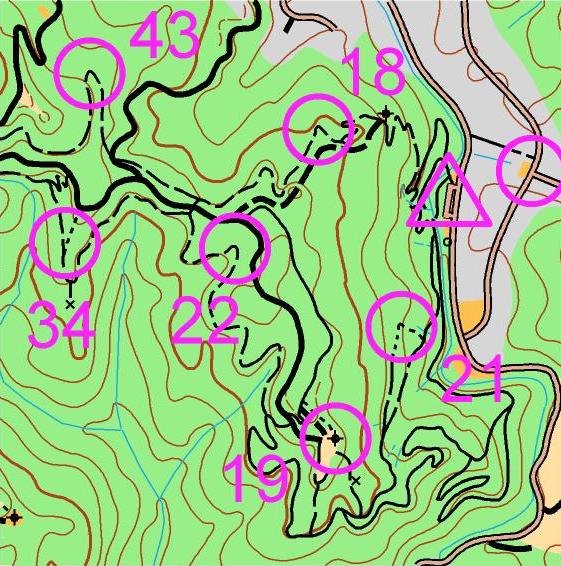
Contour lines are shown as brown squiggly lines you see on the map. They represent elevation in the landscape. The closer the lines are together the steeper the landscape. The contour interval is usually 20m, but we have 10m contours in the computer and may move to these soon.
Orienteering maps use standard orienteering mapping symbols to describe the details on the map. This information can be found in the map's legend.
In summary single-tracks are shown with narrow lines, and vehicle tracks and roads with thick lines. Good ones are solid, and dashed lines for the rest; the shorter the dash the slower the track. Single tracks on the map will be best ridden from top to bottom. Conversely 4WD tracks are best used for climbing. Good track junctions will be shown with the lines touching; a gap indicates the junction is indistinct and you will have to look carefully.
 Off-track most of the map is green, and this means forest - do not use. Open land (most of it is recently logged so pretty rough) is pale yellow and you aren't allowed to use this either. You'd be mad to want to. There are a couple of colours for "allowed to use". White means forest, allowed to use, though there's hardly any. (Think white = very light green!) Bright yellow means open land, allowed to use. Forest skid sites come into this category and they are handy navigation features too.
Mapholders
There isn't much special gear for MTB rogaines, but it helps to have the map in a holder on the bars. The best ones rotate so that you can line the map up with the terrain. See NZ MTBO web resources. But better than nothing is a piece of corflute cable-tied onto the bars. The guy from The MAPsport Shop is often at these events and stocks boards from $5 to $150.